User login
Language
Anonymous's groups in this site
User is not a member of any group.
Your groups across all your sites
User is not a member of any group.
Recent Content
Who's online
There are currently 0 users online.
You are here
 submitted by Albert Gomez
miamidade.gov
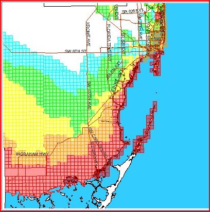
Storm Surge Planning Zones
The Miami-Dade County storm surge planning zones have been redrawn in relation to updated data which supersedes the previously-used SLOSH model. The newest generation of SLOSH model reflects major improvements, including higher resolution basin and grid data. SLOSH model grids incorporate local physical features such as geographic coastal area, bay and river shapes, water depths, bridges, etc.(Note: SLOSH – administered by NOAA - is an acronym for "Sea Lake and Overland Surge from Hurricanes.") Areas in Miami-Dade along canals and rivers and further inland have been identified as being at risk for storm surge based on this new data.
Please Note: With the new maps, each zone or portions will be evacuated depending on the hurricane’s track and projected storm surge, independent of the hurricane’s category. Upon identification of a threat the EOC or County Mayor will use local media to relay pertinent information, such as evacuations and shelter openings. It is important that you monitor the news for this information. Remember that these planning zones deal strictly with storm surge; you still need to determine if your home is safe to remain in during a hurricane.
To determine if your location is within a storm surge planning zone, visit: http://tinyurl.com/md-hurricanezone (Enter your address) or call Miami Dade Answer Center at 3-1-1.


Recent Comments