Welcome to the Miami-Dade Alerts Registration!

Welcome to the Miami-Dade Alerts Registration!

Evacuation Resource Page

Miami-Dade County:  List of Evacuation Centers

FEMA- Region IV: Social Media

Six Of 22 Miami-Dade Libraries Could Be Saved From Chopping Block

Hurricane Resource Page

The Hurricane Resource page was developed by the Florida Office of Insurance Regulation (Office) to provide useful information and links for consumers, media, and other interested parties. Please note – some of these resources were not developed by the Office, and some links will direct you to websites not maintained by the Office. This information will be updated as necessary during the 2013 Hurricane Season.

Predicting What Could Happen if Hurricane Hits


homelandsecuritynewswire.com - July 19, 2013

A Sandia National Laboratories team is gearing up for hurricane season, readying analyses to help people in the eye of a storm. The team has two jobs: conducting annual “hurricane swath” analyses of probable impacts on the Gulf Coast and East Coast, and providing quick analyses of crisis response in the face of an imminent hurricane threat to the United States. A swath analysis looks at how a hurricane might interrupt critical services and at impacts to infrastructure specific to an area, such as petroleum and petrochemical industries in Houston or financial services in New York City. It also looks at such things as the economic impact of the storm or how it could upset food deliveries.

Map Mashes Hurricane Information with Energy Infrastructure Data

                                   (FOR THE INTERACTIVE MAP - CLICK ON MAP IMAGE BELOW)


emergencymgmt.com - by Sarah Rich - July 11, 2013

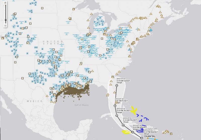
This year's hurricane season may prove a bit different for the energy sector, thanks to a newly updated interactive map, pictured (above), made available by the U.S. Energy Information Administration (EIA).

What was an existing state map launched by the agency last September now includes more than 20 layers of GIS data to plot the nation’s energy infrastructure and resources. The data can be mashed up with real-time tropical storm and hurricane information from the National Hurricane Center, so resources like offshore production rigs, pipelines, coastal refineries power plants, and energy import and exports sites can be monitored as the severe weather occurs, according to the EIA.

(READ COMPLETE ARTICLE)

EPA - National Stormwater Calculator

submitted by Albert Gomez

epa.gov

EPA’s National Stormwater Calculator is a desktop application that estimates the annual amount of rainwater and frequency of runoff from a specific site anywhere in the United States (including Puerto Rico). Estimates are based on local soil conditions, land cover, and historic rainfall records.

It is designed to be used by anyone interested in reducing runoff from a property, including

Pages

Subscribe to South Florida RSS
howdy folks